
boating INDRICA-KRASLAVA
DAUGAVA BENDS
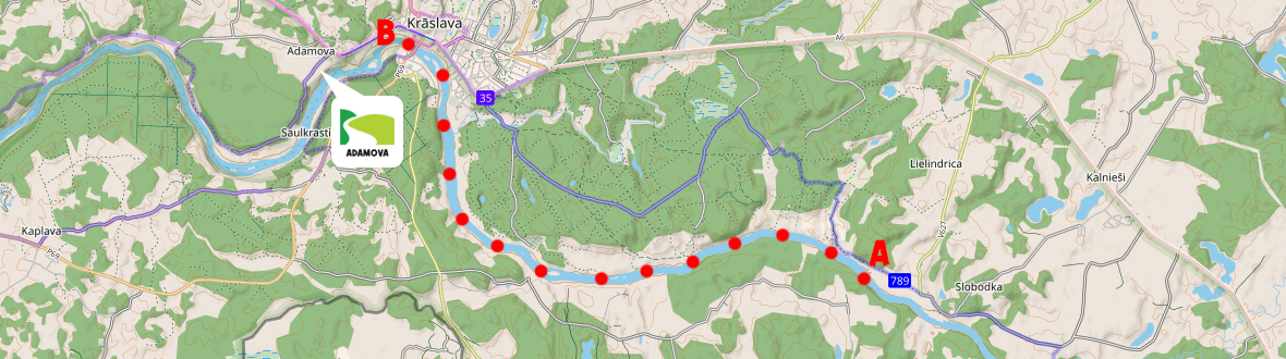
About the boating route
Number of days: 1 day;
Route length: ~ 15 km;
Route duration: ~ 4 h, duration depends on the time spent visiting sightseeing objects, the type of boat chosen, the number of people in the boat, the physical fitness level of the boaters, the water level in the river, wind direction, speed, etc.;
Difficulty level: easy;
Accommodation and rest areas: “Adamova” camping, islands and sandbars on the riverbanks can be used for recreation.
Most significant sightseeing places: Indrica Catholic Church, Krāslava, Adamova nature trail, Adamova cliff, etc.
Boat rental
You can reserve boats by phone +371 26044411 or email: kempingsadamova@gmail.com.
Most significant sightseeing places
Indrica Catholic Church
The building of the Indrica St. John the Baptist Roman Catholic Church is an architectural monument of national importance. It is one of the oldest currently known wooden Catholic churches in Latgale. Indrica Church is closely connected with the history of the Plater family. The church was built in the middle of the 17th century. With the spread of Lutheranism in Indrica, it was taken over by Protestants. In 1695, Jan Andrzej Plater converted to Catholicism, and in 1698 the church was rebuilt and handed over to the Catholics. Indrica Church has four ornate altars with wood carvings. A copy of the so-called painting of Our Lady of the Snows, made in the middle of the 18th century, is preserved in the church (the original perished in Izvalta Church in 1941). A stone wall from the end of the 17th century stretches around the church, and a free-standing bell tower built in the middle of the 19th century stands next to it. For more information, visit the Krāslava Municipality Tourism Information Centre website!
Krāslava
The settlements, hillforts, and ancient burial grounds identified in the vicinity of the town testify that the banks of the Daugava in this area have been inhabited since prehistoric times. Starting from the 8th century, archaeological evidence characteristic of Latgalians can be identified. In the 14th century, a fortified Livonian Order goods warehouse was established here, which in the middle of the 16th century became a fief manor of the Order. In 1729, the property was purchased by Count Jans Ludvigs Plāters. The Plater family purposefully developed Krāslava into the administrative, spiritual, and economic center of Latgale. After the fire of 1826, the town began to decline, but revived again in 1865 when the Daugavpils-Vitebsk railway station was opened nearby. In 1893, Krāslava was once again hit by a devastating fire. On April 16, 1923, the town of Krāslava was granted city rights. Modern Krāslava is a scenic Latvian town with largely untouched wooden architecture. For more information, visit the Krāslava Municipality Tourism Information Centre website!
Most significant sightseeing sites in Krāslava:
- The castle complex of Counts Plater with a park - an architectural monument of national importance from the 18th century. The Krāslava Tourism Information Centre and the Krāslava History and Art Museum operate in the manor complex.
- Karnicki Hill - a scenic place offering an expressive panorama of the city and associated with a romantic legend of a great love between Count Plater’s daughter Emilija and Polish officer Joseph Karnicki (Josifs Karņickis).
- Krāslava St. Ludvig Roman Catholic Church - the brightest example of Latgalian Baroque architecture. The current church was built between 1755 and 1767.
- The Augustus Stone - several stories have been recorded about the stone, mostly related to the alleged activities of the King of Poland, Augustus, here. However, the significance of the stone is likely different - it has the Plater family coat of arms and the year “1729” carved into it. In this year, Jans Ludvigs Plāters purchased Krāslava.
- Priedaine observation tower - the tower allows enjoying the panorama of the Daugava Bend (Priedaine Bend) and Krāslava from a height of 32 m.
Adamova nature trail
A well-maintained and marked nature trail that provides an opportunity to explore nature in its diversity – walk along the expressive terrain, enjoy the vast landscapes of the Daugava valley, view natural monuments, and discover the rich flora and fauna. The length of the medium-difficulty route is 2.5 km. The trail starts at the site of the former Adamova hillfort in Krāslava, where a convenient parking lot and a viewing platform are set up, offering a wide panorama of Krāslava and the Daugava valley. The Adamova hillfort was flattened in the late 1960s to build a highway over it. Visitors can see the Adamova boulder (more than 10 m3), the Adamova cliff, the Svarinski ravine, and also reach the “Adamova” campsite. For more information, visit the Krāslava Municipality Tourism Information Centre website!
Adamova cliff
The Adamova cliff with ancient ravines, as a complex geological and geomorphological formation, is one of the most significant nature areas in the Daugava Bends. The main bank cliff, which reaches a height of up to 38 m, was most likely formed in the 1930s when the floodwaters of the Daugava washed away the main bank. Compared to the mentioned period, today the cliff is heavily overgrown, with active slope processes still taking place only in some areas, where the slope angle of the cliff reaches up to 50 … 60 degrees. Next to the natural monument is the “Adamova” campsite.